Thursday, July 13, 2023

Montagne Verte

Hikers who have exhausted all the offerings of the Mont Tremblant ski resort and looking for something new and rewarding need look no further than Montagne Verte.  About a 20 minute drive from the Tremblant resort, Montagne Verte is located on the opposite side of Lac Tremblant and affords impressive panoramic views.

I won't bother providing turn by turn directions because you can search "Sentier Mongtagne Verte" and find it well marked on online maps.  There is a parking lot clearly marked on Chemin du Lac Baptiste where you will find a a couple dozen parking spots as well as an obvious trail head beside the map.  The trail is fairly moderate and according to the time stamp of our photos, we were above the tree canopy within 30 minutes and seeing the amazing views of the Tremblant ski runs.


Once at the top, you'll encounter several flat rock areas that offer wide views in multiple directions.  It's quite wide open and we open a good hour here before heading back down.  Do pack a lunch or snack because there are lots of great spots to sit and enjoy. A highly recommended trip!


Saturday, April 17, 2021

Montagne D'Argent - superb hiking


Mont Blanc as seen from one of many lookouts
In an effort to break the monotony of the COVID lockdowns, my wife scoured the Tremblant area for new outdoor activities we haven't tried yet.  A difficult task...after more than a decade in this region, we've done so much of what is on offer.  Still, she found Montagne D'Argent, a park owned by the municipality of La Conception which is about a 20-minute drive from the Tremblant resort.  You might ask why you'd drive 20 minutes for hiking when the highest peaks in the Laurentians are at the ski resort.  A fair question, and this article will tell you why.

First of all, hiking at the Tremblant resort is fantastic, as we have recounted in multiple posts.  No hike in the area affords the same "top of the world" panoramic view as you get at the peak, whether you do the climb or take the gondola to the top.  Same with the Mont Tremblant National Park...a little further afield, but a rich and varied set of hikes that are well worth the drive.  The NationalPark also offers the Via Ferrata for those who want a more extreme experience.  

But Montagne D'Argent (Silver Mountain in English) is different. Even though its peaks are less than half the size of Tremblant's, the hiking is far more rugged and the views are equally rewarding.  We visited on Easter weekend of 2021, with an unseasonably warm day.  You have to watch carefully to find it...just an inauspicious dirt parking lot on Rue de la Montagne D'argent.  Walk up the driveway and you arrive at the base camp with a small office, picnic tables and a few out-buildings that serve the year-round campers.  After we checked in and paid our day fees ($7 each for non-residents of La Conception), the attendant recommended the fullest hike that circles the outermost edges of the park.  We didn't know that the trails he suggested required a higher degree of fitness and athletic ability and so in retrospect we 50-somethings were flattered to have appeared capable of handling them.

Karen works her way up rope #1

The hike started off quite easily...a well trodden gravel path through campsites (a few occupied by hardy campers in April).  Along this flat path we passed a number of rock climbing spots - Montagne D'Argent is best known for it rock and ice climbing.  Sheer rock is on display throughout the hike, which is one of the distinguishing features from the largely woodsy hiking trails in other parks.  Before long, we turned a sharp corner and the ascent began up the spine of a stone trail.  Beautiful views of the surrounding farm land and the Riviere Rouge were almost immediately available...lookout points are frequent on these trails so you are rewarded regularly for your efforts.

The trails are abundantly marked so you never have to wonder if you've strayed, and there are occasional "you are here" maps so you can Magellan your way through the park.  The trail are also colour coded by difficulty, and we were finding the orange trail La Crete (orange is second most difficult) to be rather easy.  Until we found the surprise.  There was a sudden drop of about 10-15 feet in the trail, and the way down was via climbing ropes.  So we tossed our hiking poles to the bottom and used the ropes to rappel our way down.  That was fun!  We encountered a few of these along the orange trail and we had a lot of fun with each one. 

10 feet of ice at the base of the stairs!

Soon after, we turned onto the red trails.  The biggest difference on the reds was the depth of the drop-offs.  The rope rappels were now more like 20 feet and far more challenging.  Still manageable. but there were a few spots where we needed to plan out our footwork to get down.  Because it was early April, there were still patches of snow and ice and so in a couple spots we had fairly treacherous dealings with ice, including one spot where your only option was top slide about 10 feet on your butt to get to the bottom.  Again, all manageable, but be prepared for something that isn't the usual trail walking.  We knew something was up when the attendant asked us if we had crampons! 

After the last of the major lookout spots, we could tell we were heading back to the main camp.  It was still a considerable hike with many elevation rises and falls.  In all, it was almost a 4-hour hike, lengthened by some slow going over ice as well as a few rest spots for a snack.  Plus a cave visit that I couldn't resist (see photos below).  

We didn't venture over to see the lake, which by all accounts has a great beach as well as some cliff jumping, but we will check this out next time, likely in summer.   And there will definitely be a next time - we found Montage D'argent to be a superb hiking destination and highly recommend it!

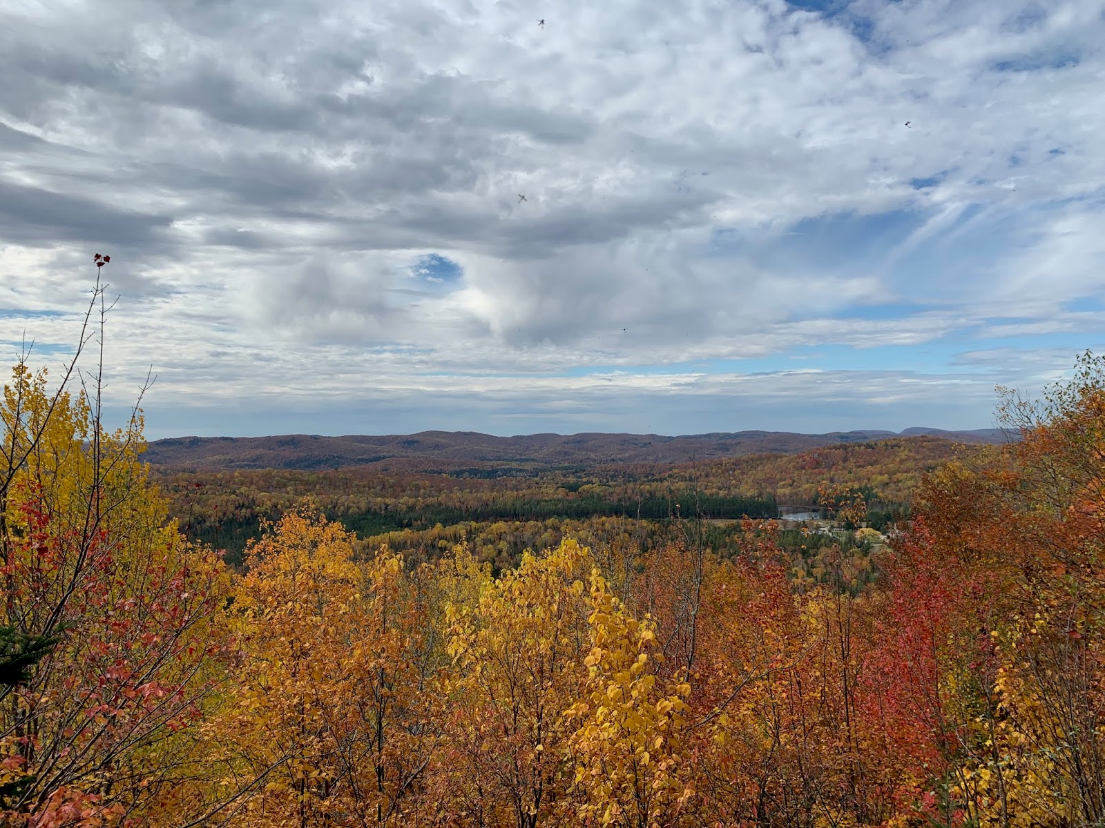
Mont Tremblant in the distance, April sun tan in the foreground (-:

Trail narrows between two large rocks

Awesome cave, ice floor, had to go in (fyi no bears)


Saturday, September 19, 2020

Hiking - Domaine St. Bernard

One of the many lookout points
My hiking posts have been by far the most popular on my blog, where I've chronicled the excursions we've done in the National Park as well as the Mont-Tremblant mountain itself.  While these are two major hiking destinations, there's a deserving but lesser known destination to try out: the Domaine St.Bernard.

The Domaine is a 1500-acre park, which I have written about in this post.  We have been coming here for years for hiking, swimming and cross-country skiing.  The hikes don't have the sweeping 360-degree vistas you get on top of Tremblant...the "mountains" at the Domaine are much smaller.  But our Thanksgiving 2019 hike on Mont St. Bernard was so great, I need to tell you all about it.  

The unfortunate part of this post is that I left it too long to actually sit down and write it so I have lost much of the detail.  That said, I can at least tell you how to get started and show you what's in store.  This route starts with a couple minutes on the Grande Allee, a wide road cut out of a planted pine forest.  After you pass the children's maze (which is a whole other story), look on the right for the entrance to R1, Hirondelle.  It's a nice single-track path paved with pine needles.

The first five minutes or so are fairly flat, and then the gradual ascent begins.  The trails are exceptionally well marked and the footpaths are well worn, so it's easy to find your way through the woods.  Based on the timestamps of my photos, you'll be rewarded with lookouts within about 20 minutes of starting out on the trails.  The pics below give you a sense of what you'll encounter along the way.  One highlight that we want to make sure you know about (and can be missed) is a beautiful view of Lac Tremblant.  At a middle point in the hike, you'll encounter a rather steep section of trail with flat rock under foot, perhaps 40 metres long.  When you're at this point, if you turn around you'll see an opening in the trees that reveals Lac Tremblant in the distance.  We discovered this by accident the first time we hiked it - we walked right past this spot and only noticed the view when we doubled back.

Enjoy the photos below and more importantly, enjoy this hike next time you're in the Domaine!

Lac Tremblant !

View of Lac Raynaud
First lookout spot

Highest lookout on Mt St. Bernard


Sunday, September 13, 2020

Hiking Mont Tremblant - North Face

Today was a sunny, warm September Saturday and so that means the fall-colours tourism was in full force at Mont Tremblant.  Karen and I were keen to try something new but avoid the crowds, and we found the perfect solution: hike the Versant Nord (north face).  After all, we had done many South Face trails and even an excursion on the Versant Soleil, starting at the Casino.  It was time to embark from the North side, even though we couldn't find much in the way of formal trails.

North side parking lot - deserted!

These of course are COIVID times, so we arrived to find an empty and gated parking lot upon arrival.  (All the action is on the highly developed south side). We parked on the road outside the gates, as had roughly a dozen others, and headed for the mountain.  For some reason, we decided to walk up the black diamond runs on the left of the Duncan chairlift.  This would turn out to be a very direct but taxing way to ascend.   We learned later that taking the green runs to the right of the Expo chair lift would afford a much gentler ascent, but more on that later.


10 minutes in, already great views

Having skied these runs so frequently, we knew that there would be some great views of the Laurentians.  Indeed, you don't have to hike far up to to start getting beautiful vistas.  To keep our heart rate under control, we stopped frequently for a breather and took in the views, each one more dramatic than the last as we got higher up.  Taking this grassy route up was fine - few established paths but the occasional set of tire tracks worn into the ground by maintenance vehicles.  We knew we weren't the only ones hiking this slope as we found a few informal paths through the longer grasses.  One word of advice: wear waterproof hiking boots as there is ongoing runoff of water and you'll get a couple soakers along the way (I did).


Nearing the top on Saute Moutons
We started heating up in the sunshine, and decided to cool off by cutting through the woods.  We found a section of forest that we suspected was cleared for glade skiing, and indeed it was the Boiling Kettle glade run.  We emerged on the other side, and soon saw the Duncan chair lift up ahead.  It was really sunny up there, almost like we were getting close to the top.  We seriously doubted that...we hiked the south face a couple years ago and hit a false summit after what seemed like a couple hours of hiking.  Anyway we pushed on, tackling some rather steep but climbable terrain.  After 20 minutes we saw the communication tower that sits atop the summit.  We did it!  (Another word of advice - bring hiking poles if you have them.  Even on flatter terrain, they are a life saver.)

On our way down

We had read that reaching the summit on the north side could take anywhere from 60 minutes to three hours, depending on route and fitness level.  We finished the climb in about 90 minutes which included plenty of breaks, a real surprise.  At the top, there were crowds of people but plenty of room to socially distance.  The lineup for the gondola ride down was quite lengthy, which we walked right past, a little smug in our knowledge that we'd be getting down on our own.  We found a gravel path that led towards the "zone d'apprentissage", a twisting green run that leads relatively gently to the bottom.  In case we were getting a little too smug, we were passed by an older gentleman running up the mountain, and two mountain bikers cycling up to the top for another speedy descent.  The trail down turned into a gravel service road, which actually made for a couple twisted ankles as the stones rolled under your feet.  We opted instead to head down one of the grassy ski runs.

Amazing cascade

Just as we were nearing the bottom, one final surprise emerged.  We could hear the rushing of water all along the path down but couldn't see the stream.  We were coming to the end of run #77, Beauchemin Bas, and finally there was a cut out in the forest that revealed a beautiful cascade.  On a hotter day, we would have used this to soak our feet, cool down and have a snack.  Next time!  

This was an excellent hike for those who want all the beauty but none of the crowds.  Three hours from start to finish and many rewards along the way, highly recommended!

Panoramic views from the summit


Saturday, July 6, 2019

Tremblant Fly Fishing - NaturAventur

Karen sports the latest fishing fashions
Both Karen and I fished with our dads when we were kids.  Perhaps you did too...some fond memories indeed, although some rough patches too.  You were always subject to the preferences of the adults, you fished as long as they wanted to even if you were tired, and heaven help you if ever snagged your line in rocks or trees.  Fast forward to today: now we're the grownups, and we're fishing on our own terms.  Karen and I took a fly fishing expedition this week in Tremblant and it was great.


We had no fishing gear, no experience in fly fishing (except for a brief afternoon about 10 years ago) and no idea where to go in Tremblant, except that we preferred a river experience if possible.  We found NaturAventur online, and easily booked an afternoon river expedition with Denis Landreville.  Denis is an avid fly fisher as well as a conservationist in the Tremblant region, so we found the right person to guide us.

Denis kindly untangles Karen's line
We started with a brief lesson on the basics of casting and fishing technique, quite different from the fishing we did as kids.  We then got outfitted with waders, boots and rods and we were off.  While the river beside the NaturAventur "office" was quite suitable, Denis chose to take us to a more technical part of the Diable river along Chemin Duplessis, past the turnoff for the casino.  Park along the side of the road (marked with fly fishing signs), a brief trek down through the woods, and you're on the shore of the rocky Diable river.

We worked a couple different sections of the river with one-on-one coaching from Denis on how to spot the calmer waters amid the rocks where the fish were more likely to be lurking.  Denis was very patient with us beginners, untangling lines and replacing the odd lost fly.  Given his depth of expertise and years in the industry, I know he would be an equally good guide for experienced anglers.

Karen goes deep!
 It was a very hot day, and you sweat a bit in the hip waders, so bring plenty of water if you choose this adventure.  If you have your own fishing gear, that's fine.  If you prefer to simply rent gear and head out on your own, Denis can suit you up for that as well.  We really enjoyed our day and highly recommend this for beginners and experts alike!